Thursday, May 31, 2007

Port-au-Prince International-Constanza


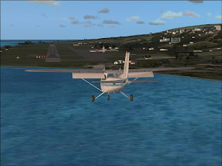
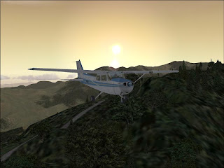
It is good to be back in the (virtual) air. I have been out of the cockpit for about two weeks to catch the blog up. Since that was taken care of, it was time to get back in the cockpit. Already in Haiti, I took off from runway 10 at Port-au-Prince (PAP/MTPP) and headed a bit north of due east. Quickly it became clear that my normal cruising altitude of 2000 feet would be inadequate, and I began a climb, eventually topping out at 6100 feet. The flight afforded me some great views of mountains and some great sunset views. Constanza (COZ/MDCZ) kind of snuck up on me, and I quickly descended to 5000 feet, about 1000 above runway altitude. I entered the right downwind leg for runway 8, but as I flew it, I had to climb to avoid mountians. Not something you want to be doing in the pattern. I readjusted to fly the pattern for runway 26. I flew the pattern too close, and as a result I tried something a little funky for the approach. I flew a half figure 8 ahead of the runway, and I entered final at the threshold. I flew the whole thing at a hundred feet or so above runway height. I guess I was a little rusty.

MTPP-MDCZ

Sunday, May 27, 2007

Gustavo Rizo-Port-au-Prince International


After spending the night in Baracoa, it was time to head east. I took off from Runway 34 and then banked left to turn almost 180 degrees. I returned the plane to straight and level flight. I continued east, leaving Cuba for the last time on the tour. I continued across the Windward Passage. I readjusted my course further south to head towards Port-au-Prince (PAP/MTPP). The flight was going too smoothly. As I neared Port-au-Prince, I flew over some mountainous terrain. I didn't pull up in time, and I slammed into the side of the hill. As always, I put myself back where I had been, and this time climbed excessively high to insure I wouldn't crash again. The straight-in approach went well and I landed beautifully. A near-perfect leg.

Note: with this update complete, I am caught up with all the legs I have flown before I started the blog. From now on, all updates will be made as I fly the various legs. This should make the updates more detailed.

MUBA-MTPP

NAS Guantanamo Bay-Gustavo Rizo


After topping off the tank, I took off and headed north towards Gustavo Rizo Airport (BCA/MUBA) in Baracoa. I climbed to 1200 feet since the airport was close. However, terrain forced me to climb to an eventual altitude of 4500 feet. The terrain and sunset made for a beautiful 45 minute flight. My descent was iffy due to being too high. I still managed to land it. Good thing I have stress damage turned off.

MUGM-MUHA

Norman Manley International-NAS Guantanamo Bay


After a quick stop in Kingston, I took off and headed north for NAS Guantanamo Bay (MUGM). As I headed north, I flew towards the Blue Mountains, which are home to Jamaica's highest point, Blue Mountain Peak. I attempted to level off at 2000 feet, but that would have put me on a crash course. I tried leveling off at successive intervals of 1000 feet, but each time the mountains kept going higher. Finally I was able to level off at 6000 feet. Coming over the top of the mountain range afforded me a great view. I continued north towards Cuba. The approach into NAS Guantanamo Bay went great, and I landed beautifully.

MKJP-MUGM

Sir Donald Sangster International-Norman Manley International


Next I headed southwest across the Islan towards the capital, Kingston. After taking off, I banked right and climbed to around 2000 feet. As I flew further inland, I became too close to the ground, so I climbed to about 3000 feet. The rest of the fight went uneventfully. The view along the way were spectacular. My descent and approach into Kingston went well. Another good leg down.

MKJS-MKJP

Owen Roberts Intenational-Sir Donald Sangster International


My next flight took me east to beautiful Jamaica. After taking off from Roberts International (GCM/MWCR), I climbed to 2000 feet and leveled off. The flight went smoothly and uneventfully. I entered the base leg for runway 7 at Sangster International (MBJ/MKJS). I entered the approach a bit low, so I slowed my descent and made a great sunset landing. A great leg. [Note I didn't attempt at making a Ya, mon reference]

MWCR-MKJS

José Martí International-Owen Roberts International


After spending the night in Havana, it was time to head south to the Cayman Islands. I took off from runway 4. As I got to 500 feet AGL, I banked to the left and headed towards Grand Cayman and Owen Roberts International (GCM/MWCR). I leveled off at the usual 2000 feet and enjoyed a leisurely 2 and a half hour flight. My approach was iffy, as I came in on the base leg too high and off line. Rather than make a go around, I put a plane in a dive and ended up landing only a couple hundred feet or so beyond the threshold. I guess all is well that ends well.

MUHA-MWCR

Lynden Pidling International-José Martí International


Next, I headed south. On takeoff from Pidling International (NAS/MYNN), I stalled the plane as I was enjoying the view. I qickly recovered and resumed my climb. I leveled out at around 2000 feet and managed to trim the plane to a perfect 0 ft/min vertical speed, which is not easy in a C172. That was quickly eradicated as I encounted a large pocket of turbulence near the coast of Andros Island. Forunately the balance of the more than three hour flight was uneventful. I entered Cuban Airspace, and after navigating some restricted and dangerous airspace, I entered the down wind leg for runway 4. The pattern went well, albeit a bit low, and the I landed decently. The sunset made it a landing to remember.

MYNN-MUHA

Little Whale Cay-Lynden Pindling International


After getting my plane back on the runway, I took off and headed south for the half hour flight to Lynden Pindling International (NAS/MYNN) near Nassau. The flight went pretty well. I made a straight-in approach to runway 14, which went very well. Island hopping is great.

MYZ3-MYNN

Saturday, May 26, 2007

Key West International-Little Whale Cay


Next, I headed east to the Bahamas. After taking off from Key West (EYW/KEYW), I flew along the Florida Keys. I then exited US Airspace. It was around 30 minutes before I entered Bahamian airspace, although strangely you are under the control of the Miami Center far into the Bahamas. After more than two hours in the air, I cam in for the approach at Little Whale Cay (MYZ3), a private Island in the Berry Islands Archepelago north of Nassau. My first approach was bad and made a go around. My second wasn't much better, and I landed a good ways down the 2000 foot runway, and as a result, I slid off the end. The good thing about a private island is that no one can see you screw up a landing.

KEYW-4FL3

Fellsmere-Key West Intenational


Next, I headed to what may be the southernmost airport in the Continental US. After departing Fellsmere (4FL3), I headed southwest across Florida. After reaching the Gulf Coast (and encountering some turbulence), I headed across the Gulf for Key West International (EYW/KEYW). I ended up flying the pattern to close to the airport, which left me too little time to descend, and as a result, I made a go around. The next attempt was better, albeit stil not great, and I landed pretty near the threshold. The east coast portion of the tour was complete.

4FL3-KEYW

NASA Shuttle Landing Facility-Fellsmere


With my plane pulled out of the pond, I was ready to head out again. After filling up, I pushed back (first time I actually used pushback), and then took off from runway 33. After taking off, I stayed low and flew over to the launchpad area (something that would definately cause you to lose your license in real life-but hey, this is FSX) and took a look around. I then headed south to Fellsmere (4FL3). I originally intended to land on Runway 9, but I missed the approach. As a result, I repositioned myself to land on runway 27. This proved tricky due to the fact that it was a grass strip, and because there was an antenna right in the way (go figure). Regarless, I made a decent approach and landed the plane without a hitch. I love sunset landings.

KTTS-4FL3

World's Greatest Aircraft Collection-NASA Shuttle Landing Facility


After viewing the Museum's fascinating collection, it was time to get back into the air. Through the magic of simulation, my C172 was waiting for me at the museum. I hopped in, and took off from one of the Museum's two grass runways. I climbed to 2000 feet as usual. I then headed south, again to avoid the heavy traffic area around MCO. After flying past the Class B airspace, I headed east and then north. I made the straight in approach to the NASA Shuttle Landing Facility (TTS/KTTS formerly and in FSX X68). The approach went very well. I landed on Runway 33. Unfortunately, the only taxiway is at the threshold to Runway 33. I did not know this at the time. As a result, I taxiied all the way down the remainder of the 15000 feet of runway, all the while ATC was telling me to turn off the runway. At the end I spotted what I thought was a taxiway (in reality it was a service road) and tried to turn off. During the long taxi, I had accelerated to 70 kts (rotate is at 55) and did not think it necasary to slow down for the turnoff. I ended up being wrong, and slid off the runway. Unable to regain control, I ended up in a pond. What a way to end a flight.

FA08-KTTS

Thursday, May 24, 2007

Epcot Center-World's Greatest Aircraft Collection


After a couple of runs on It's a Small World and Space Mountain it was time to head out. I took off from Epcot Center (44FD) and headed south for the short (17 NM) flight to the World's Greatest Aircraft Collection Museum. The flight was enjoyable, and the approach was good. The museum is modeled beautifully. Thankfully, there is no DC-3 on its nose.

44FD-FA08

Ormand Beach Municipal-Epcot Center


After flying from New York to Florida in my trusty C172, it was time to switch aircraft for a couple of flights. At Ormand Beach (OMN/KOMN) I picked up an Aircreation Ultralight Trike. I would need the extreme STOL ability of the Ultralight to land at my next destination, Epcot Center Ultralight Flight park (44FD). Yes, Disney World has an airport. After taking off from Ormond, I headed southwest towards Orlando. Not wanting to get in the way of incoming Airbuses and Boeings, I avoided the Class B airspace around KMCO. The flight was pretty quick. Before I landed, I took some time to see the pieces of Disney World that are modeled in FSX. These include the Cinderella Castle, Space Mountain, and Spaceship Earth. They are pretty well modeled, although the first two are strangley covered in a dense growth of trees. After visiting the airport, I headed to land. Like Safford (GA20), the grass runway made for a difficult approach. In real life, the airport is a circular pad. In FSX, it has a E/W runway designation. Problem is, the runway is indicated in GPS and on the map as running N/S. Combine that with FSX's poor resolution of grass runways, and the approach wasn't easy. After several attempts, I was able to land the trike, and surprisingly was able to stop it with a decent amount of runway left. It was time to go see Mickey.

KOMN-44FD

George T. Lewis-Ormand Beach Municipal


After taking in the scenery at Cedar Key (CDK/KCDK), I headed east towards the Atlantic Coast. The flight path for the flight to Ormand Beach (OMN/KOMN) was slightly more complex, as there were a number of restricted airspaces and military operation zones, which I had to fly under and around. The approach, which took me right over the city was beautiful and I flew it pretty well. Another good leg completed.

KCDK-KOMN

Stafford-George T. Lewis


After a quick layover on Cumberland Island, I took off from the landing strip/lawn (see above image) and headed southwest across the sunshine state. Leveling off at 2000 feet, I passed Jacksonville International, and was able to take in some great scenery. The descent and approach to George T. Lewis (CDK/KCDK) was very good. The airport is located on Cedar Keyin the "elbow" of florida, between the panhandle and the peninsula. I highly reccomend it.

GA20-KCDK

Wednesday, May 23, 2007

Clayton County-Stafford


After a pit stop in Atlanta, I headed south. Taking off from Clayton County (4A7), I leveled off at the usual 2000 feet. The flight was pretty uneventful, and it was smooth all the way to my destination in the Sea Islands. My flight path took me over a similar route to the one I had used the day before. I descended into Stafford (GA20), a private strip on Cumberland Island, GA. The approach was difficult because a) the strip is grass, and wasn't clearly defined in FSX and b) the runway wasn't named by its heading, but rather NW/SE. This made the approach difficult, but clear weather made it doable. Not an airstrip I'd necessarily recommend, but a decent one nonetheless.

4A7-GA20

Hilton Head-Clayton County


Next I departed Hilton Head (HXD/KHXD) and headed northwest. I leveled off at 2000 feet. The cruise was uneventful, and as I neared Clayton County (4A7) I began my descent and did my best to stay out of Atlanta's Class B airspace. I entered the pattern on the downwind leg. While flying the Pattern I passed Atlanta Motor Speedway, which in FSX looks like an oval-shaped road with a big set of bleachers. The approach went well, and although I landed a bit off center, it was a good leg. The hardest part was finding a parking space at the airport. I guess driving and flying aren't all that different.

KHXD-A7

First Flight-Hilton Head


My next flight took me down the Carolina coast. The takeoff proved to be the most eventful portion of the flight. As I rotated from First Flight (FFA/KFFA), the plane rolled to the right (under calm conditions). Why this happened I do not know (most likely my joystick, which has proven to be problematic in the past). I rolled back, and continued my climb a good 30 degrees from runway heading. I then headed south a long the Atlantic Coast. The flight was pretty long (over three hours), but the spectacular coastal views provided for an enjoyale flight. The flight proved uneventful. My approach into Hilton Head(HXD/KHXD) was the best so far (a little bit low, but that's OK). My flying skills are improving.

KFFA-KHXD

Mountain Air-First Flight


This next flight took me across North Carolina. After taking off from Mountain Air (2NC0), I flew over the Appalachian Mountains for the final time (until I fly down and back up through South America). I then continued across North Carolina. This flight was one of my longest at over three hours. I started my descent about 50 miles or so from the North Carolina Coast. As I neared the Atlantic, I had to steer around some of the restricted and prohibited airspace that covers the majority of the Carolina coast. As I entered the pattern for first flight (FFA/KFFA), it became apparent that I was too high, and I made a go around. The next approach put me too low, but I landed decently (albeit a little bit off center). I used the full runway for my rollout. I stopped on the turn area, in order to observe the beautifully modeled area where the first flight occured. Amazing how far we've come, and how so much was the result of that one flight. The Wright Brothers have my most sincere gratitude.

2NC0-KFFA

Mingo County-Mountain Air


My next leg took me almost due South to North Carolina. After taking off from Mingo County, I climbed to the usual 2000 feet. The rest of the hour or so flight went smoothly. As I closed in on Mountain Air (2NC0) in Burnsville, NC, I climbed to about 4500 feet. This positioned me a little low while flying the pattern, but considering in the past I have had to fly go arounds due to being high, it was a welcome change. As a result, the pattern was the best I've flown. The approach was a little off, but the landing ended up being pretty good. Mountain Air is a beautiful airport, which I highly reccomend flying to. Unfortunately, the FSX version still doesn't due the real airport justice. See below to see what I mean:


4I0-2NC0

Falwell-Mingo County


My next flight took me back over the Appalachian Mountains. After taking off from Falwell (W24) I flew west. The nearly two hour flight went uneventful until my approach into Mingo County (noticing a theme?). Against my better judgement, I intitiated a straight-in approach several miles out (at night). Like previous simialar attempts, I missed the approach and went around. The next approach went poorly as well, and I ended up nose diving a good ways down the runway. I slid off the runway as I tried to to a high speed turn off. On a positive note, my taxiing was much improved.

W24-4I0

Balcony Downs-Falwell


After getting my trusty C172 pulled out of the woods, I got ready to take off for Falwell Airport in Lynchburg, VA (W24). I only wish It were that simple. I opened the throttle to full, and went barreling down the 1200 foot strip, I lifted off, and then, I got the green strip at the top of the screen. CRASH. I had clipped a tree on he climb up. The Beautiful thing about FSX is that you get unlimited do-overs. Well I got my plane reset on the runway and took off again. And again, I clipped a tree. Again, I got plane reset on the runway. I set my flaps to full (30 degrees-which I realize was excessive now), and started the takeoff roll. After rotating, I banked hard to the right, and successfully climbed out of Balcony Downs. Third times a charm? I was definately glad to be away from that place. I then continued on to Falwell, wich took me back over the Appalachians. My initial approach proved too high, and I ended up having to go around, a procedure that was becoming routine. My next one was pretty good, and I landed the plane well. I was glad to see that the day before was a fluke.

VA43-W24

Sunday, May 20, 2007

Lanseair Farms-Balcony Downs


My next flight took me over the Appalachian Mountains to another one of Doherty's Difficult and Dangerous approaches, one that definately deserves the title. I took off and climbed to 2000 feet. The first three quarters of the flight passed uneventfully. A ridge was coming up fast, and I was clearly too low. As I tried to pull up, the controls felt numb. I had accidentally engaged the autopilot, which at the time I hadn't thought to disengage. Not realizing this, I crashed into the Appalachian Mountains. The game then returned me to Lanseair Farms. Not wanting to repeat the two hours of flight I had already completed, I used the map to move me to the approximate location of where I was before the crash. This time I successfully climbed over the mountains, and continued on towards Balcony Downs. Ready to get this flight behind me, I entered the base leg for Runway 35, a 1200 foot grass strip. Landing on a small grass strip isn't easy, and compounded with my skill level at the time, probably wasn't a great idea to attempt at night. After several go-arounds this seemed to be the case. After coming in too high, I decided I'd put the plane on the ground no matter what. Putting the plan in a near nose dive, I missed the runway completely and crashed into the surrounding clearing. It was time to stop for the night.

MD97-VA43